Submitted by Ken Meintzer
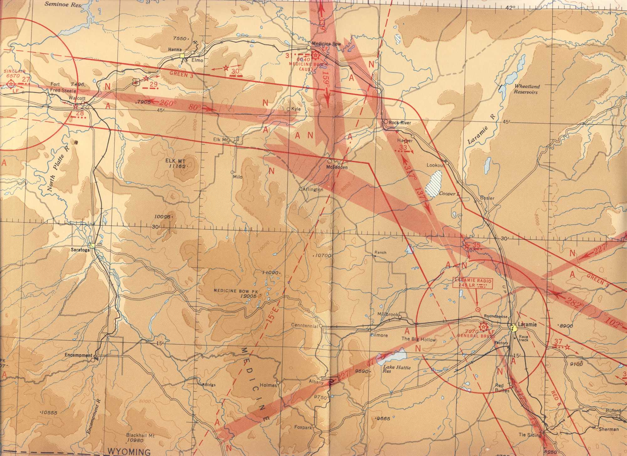
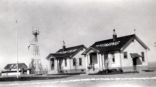
1945-1946 Medicine Bow Aeronautical Chart, Wyoming
Submitted by Ken Meintzer
1945-1946 Medicine Bow Aeronautical Chart, Wyoming
A wonderful document (PDF format) written and produced by Betty Jean Cruickshank and prepared by Ann M. Kreiser 2007, in memory of Betty Jean’s husband, Edwin M. Cruickshank.
View Full Document (20mb)
Photos of Medicine Bow #32 Radio Beacon, Wyoming, 2006
Photos submitted by Steve Wolff, Wyoming
Mr. Wolff is looking for assistance in restoring this site to it’s original condition.
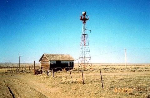
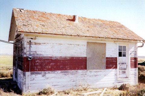
Medicine Bow building looking northeast. Typical of government built beacon sites, this building is 14×22 feet with a 51 foot airway tower. About 2/3 the way up the tower you can see the catwalk that leads out to the windsock. Between the building and the tower extends the sidewalk terminating in an arrow pointing towards the next beacon site, in this case, pointing to Rock River beacon. The whole affair was lighted from overhead so it could be seen at night.
Construction started in 1929 and was completed in 1930. According to the Aircraft Year Book, this site was the last station constructed to complete the entire NYC-SFO Low Frequency Range system. The building in this photo is very solid. It’s two rooms, one for living quarters and the other, a much smaller room, contained the radio gear and later in history, teletype. It was heated with a coal stove and electric power was supplied locally to operate the electrical equipment. In case of power failure a 550 gallon fuel tank (missing) supplied fuel to run a generator. The fuel tank was normally located between the caretakers quarters (above building) and the beacon tower.
Historical note: The Union Pacific Railroad is very close and Highway 30, the first to connect the Midwest with the West is 1 1/2 miles away. The Overland Trail from the 1800’s is very close and of course this Low Frequency Airway. They all converge at this point! Mr. Wolff is looking for assistance in restoring this site to it’s original condition.
______________
The Department of Commerce demanded these sites be kept in pristine condition including mowing lawns. Flight check pilots were always complaining about weeds up against buildings.
Interesting Side Note: The 1935 mystery novel, Obelists Fly High by C. Daly King, features a detailed description of a transcontinental flight in a Boeing 247, with much of the plot action occurring during an emergency bad weather stop at Medicine Bow field.
______________
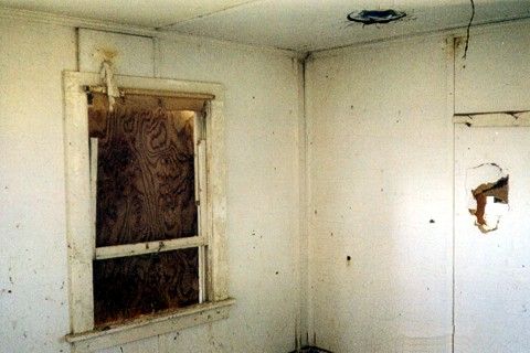
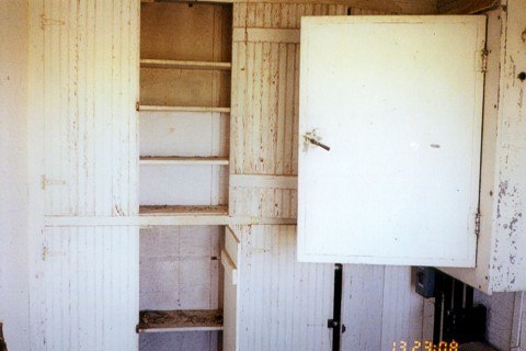 Interior photo. Open cabinet door leads to the junction box located on the north wall. Cabinets would hold fuses, signal flares, and other items.
______________
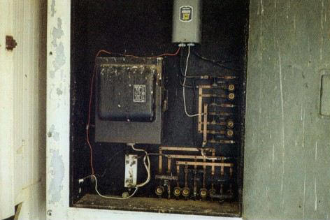 Interior photo. North wall cabinet contains a Westinghouse switch box and circuits.
______________
 Interior photo
______________
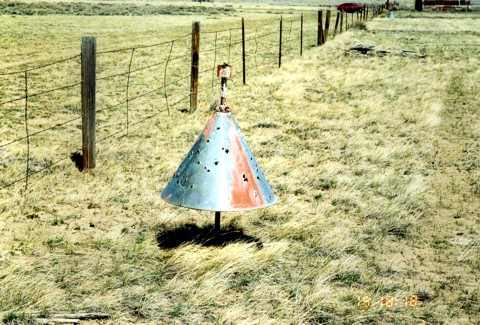 This bullet-riddled boundary cone is located on the west end of the beacon site, inside the fenced boundary
______________
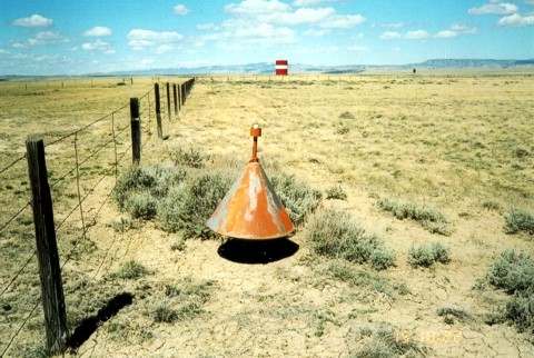 This boundary cone is located on the north end of the beacon site. The red and white tank in the background is the water supply for the city of Medicine Bow.
______________
 Boundary cone looking south east. The cone and stanchions are in place with wood markers albeit warped and faded.
______________
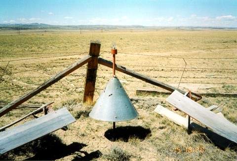 This boundary cone is located in the south east corner of the site and still houses its original 34 watt light bulb
______________
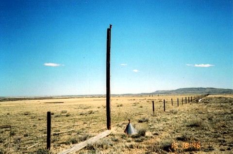 Obstruction pole on the approach end of the runway. Photo is looking north east.
______________
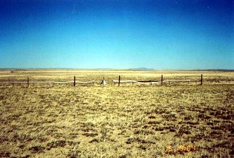
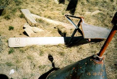 This boundary cone is located in the south east corner of the site. A U.S. concrete property marker can be seen laying on the ground along with the triangular stanchion for supporting 1×16 red and white wood runway markers.
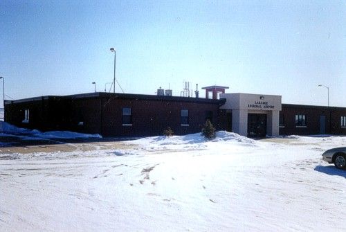
Photo submitted by Steve Wolff
Laramie FSS (LAR), Wyoming (date unknown)
Laramie FSS was commissioned 1927 and decommissioned on September 29, 1991. Laramie FSS was located on General Brees Filed. Like all Wyoming FSS’s the Airport/Facility Directory listed special remarks to advise pilots of hazards on and in the vicinity of the airport.
Antelope were the usual hazard to aircraft, but at Laramie large flocks of sea gulls or formations of white cranes migrating often disrupted airport traffic. Heavy general aviation during the school year was normal as enthusiasts flew in for major sports events at the University of Wyoming located at Laramie.
In 1978 competing against more that 30 FSS’s in North and South Dakota, Montana, Utah, Colorado, and Wyoming. Laramie FSS earned the regional award for Flight Service Station of the Year for the second time. The station earned the award based on 68,000 flight services, 22,100 airport advisories, 60 airman examinations, and 24-hour weather observations provided by a staffing of five specialists. Above history researched by Marilyn Maines in 1990 (retired 2001)
______________
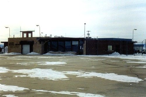
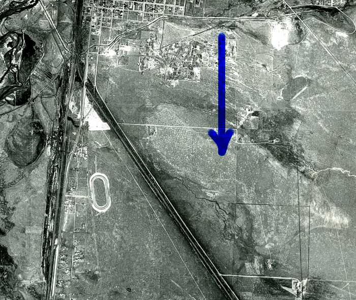
Photo submitted by Steve Wolff
Laramie CAA Intermediate Field (LAR), Wyoming, Site 37
Soil survey photo, June 30, 1947. The arrow points to the general location of the 115 acre former CAA intermediate field (the lighter shaded area). Most of it is covered up now with Mini storages. Some underground cable still remains. The field was probably in use between 1923 to 1934.
Medicine Bow Radio, Wyoming (date unknown)
Construction started in 1929 and was completed in 1930. According to the Aircraft Year Book, this site was the last station constructed to complete the entire NYC-SFO Low Frequency Range system. The building in this photo is very solid. It’s two rooms, one for living quarters and the other, a much smaller room, contained the radio gear and later in history, teletype. It was heated with a coal stove and electric power was supplied locally to operate the electrical equipment. In case of power failure a 550 gallon fuel tank (missing) supplied fuel to run a generator. The fuel tank was normally located between the caretakers quarters (above building) and the beacon tower.
Historical note: The Union Pacific Railroad is very close and Highway 30, the first to connect the Midwest with the West is 1 1/2 miles away. The Overland Trail from the 1800’s is very close and of course this Low Frequency Airway. They all converge at this point!
Photos and information submitted by Steve Wolff, Laramie, Wyoming
![]()
Photos and information submitted by Steve Wolff, Laramie, WY
Knobbs Radio Airway Beacon #26A, Wyoming, May 15, 2006
This is the radio airway beacon powerhouse building from site #26. You can just make out the 26A painted on the roof. The roof measures 10′ x 14′ and contains two windows and one door. On top of the roof is a IONA ventilator. Researcher Steve Wolff, located this building sitting in a junkyard.
Submitted by Steve Wolff
Latham Radio, Site 23, Wyoming (year unknown)
![]()
Photos and historical data submitted by Steve Wolff
Laramie FSS Radio Beacon (LAR), Wyoming
Laramie FSS was commissioned 1927 and decommissioned on September 29, 1991. This building is the former FSS station at Laramie — now a terminal.
The rectangle white sign is a 90 year old airway beacon (as of 2007). These were manufactured by American Gas Accumulator Co., Elizabeth, NJ, USA, and were powered by acetylene gas allowing beacons to operate for up to 6 months unattended. This beacon is missing the six foot pylon that attaches to the top of the unit in the photo. On top of the pylon would be the prismatic lens that flashed 150 times per minute and could be seen about 10 miles distant. Usually these were placed every three miles between the 50 foot towers. This short one was used in the plains where there were no obstructions. Bigger ones on 21′ – 51′ & 84′ towers were also used. This particular beacon is owned by a private party.
There were a string of these beacons from New York City to San Francisco in the early ’20’s before any navigational aids appeared on the scene. They also had a sun switch that turned the beacon on/off with darkness/sunlight. Hi tech!! Very rare find. It appears the globe is missing.
______________
![]()
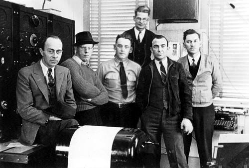
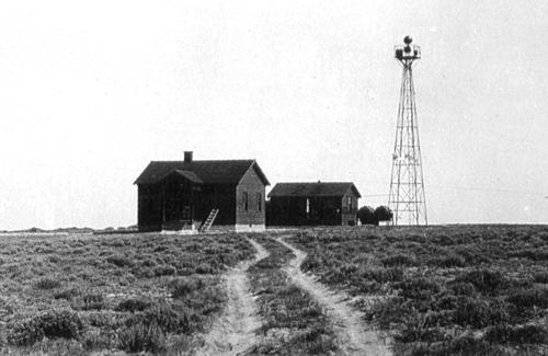
Photo taken by Kermit Karns and submitted by John Spencer
Cherokee, Wyoming INSAC Radio Crew, Site 24, 1940
Crew names, left to right, Cressie W. Hamre, E. G. Sins, Joseph Arlt, Arthur M. Brukhardt (rear), Chief; Earnest G. Igo, and Percy Spencer.
John Spencer, son of Percy Spencer (far right), said his father joined the CAA in 1940, and his first assignment was at the Cherokee Airways Station in Wyoming, where this photo was taken, according to his notes on the back of the print. See letter of employment offer, dated January 2, 1940 below.
______________
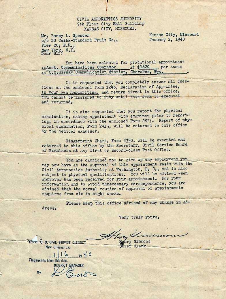 Offer of Employment Letter, Cherokee, Wyoming, Radio Site 24, January 2, 1940
Letter received from the Civil Aeronautics Authority in Kansas City, KS, offering employment to Percy Spencer
______________
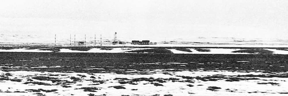 Photo taken by Kermit Karns and submitted by John Spencer
Panorama view of the Cherokee, Wyoming Radio Station
______________
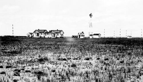 Photo taken by Percy Spencer and submitted by his son, John Spencer
The Cherokee, Wyoming Radio Station rested at 7,070 feet above sea lever