Rock Springs FSS History

History of Rock Springs Flight Service

Submitted by Casper AFSS, Wyoming

Marilyn Maines (retired 2001) is author of the following history.  She spent many hours researching data at the local Casper library.  Marilyn,  thank you for caring.

Rock Springs FSS (RKS), Wyoming

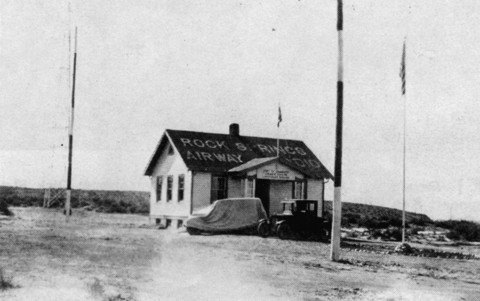
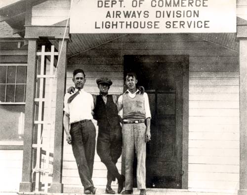
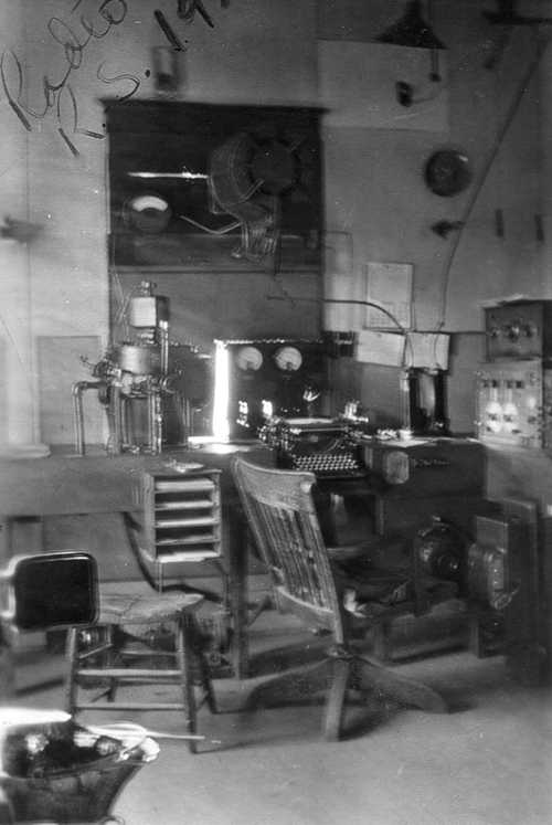
Rock Springs FSS opened in 1920 and operated continuously for 70 years. Originally established by the Post Office Department as one of the first beacon stations on the transcontinental air mail route, Rock Springs later was commissioned by the Civil Aeronautics Authority as one of the first five FSS’s in the U.S. Air Mail Radio Stations, also called Beacon Stations, along the Central Division of the Air Mail Service route from Cheyenne to Salt Lake City were located at Cheyenne, Laramie, Medicine Bow, Cherokee (about 20 miles west of Rawlins), Rock Springs, Bitter Creek, and Knight (near Evanston). The beacon stations provided current weather information and local field condition reports to air mail pilots operating open cockpit aircraft which were challenged by the high terrain and treacherous weather associated with the Rock Mountains.

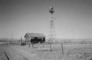
Rock Springs was a terminal landing field with non-glare electric boundary lights placed 150 feet apart around the landing area. Eight thousand feet of cable was trenched in to connect the lights. The station also maintained a 36-inch arc light (searchlight) of 500,000,000 candle power to illuminate the landing field. At 25 mile intervals, 500,000 candle power rotating airway beacons were operated by attendants on duty every night to ensure safety for the air mail pilots in case of emergency landings. The beacon at Rock Springs was 1,000 ft. above the landing field on White Mountain.

The Air Mail Service used excess aircraft and aircraft parts available after the war. Daring pilots had to traverse the east-west terrain of southern Wyoming without supplemental oxygen. Personnel at the beacon stations were on duty to monitor the comings and going of aircraft landing at Rock Springs to transfer mail from one “air ship” to another. Almost from the beginning, air mail delivery was a success. On Sunday, October 12, 1924, 1,130 pounds of mail cleared east and west from the Rock Springs field. Coast-to-coast air mail service took between 55 and 60 hours while rail time on the transcontinental run was 90 hours if there were no delays.

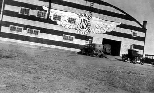
In 1921 the Rock Springs airport was located near White Mountain. In November 1930 a new $45,000.00 hangar was dedicated at the new out-of-town location. The new hangar would accommodate two 18-passenger airplanes and had a “modernly equipped” waiting room. The airport and beacon station were busy immediately due to their location on the lowest topographical east-west route through the Rocky Mountains. Early aviators needed this lower terrain route due to their physical limitations in an open cockpit aircraft.

In 1965 the current airport terminal was built, the runway was lengthened to 10,000 feet, and the new brick building that housed the FSS and Airway Facilities was finished. Scheduled airline service was provided to meet air travel demands during the oil boom. By the late 1970’s air traffic services had increased so much that Rock Springs FSS was upgraded to a Level II FSS with the journeyman grade of GS-10. Rock Springs FSS had nine Wyoming airports and one Utah airport in its flight plan area. This large number of public-use airports and the four radio navigation aids were good indicators of the complexity of the airway structure of immediate concern to Rock Springs FSS. They had the responsibility to monitor the navigation aids, advise maintenance crews of malfunctions, and disseminate information on abnormal operations to pilots.

Rock Springs, Rawlins, and Laramie have always been major stops for cross-country flights between the west coast and Oshkosh, WI, as homebuilt and experimental aircraft make the annual trip to the Experimental Aircraft Associations world-class aviation event. Rock Springs is also a turning or stopping point in the Jackpot Air Race from Lander, WY, to Reno, NV, which has been held each April since 1969.

Special events and people are numerous in Rock Springs FSS’s history. During the early 1940’s the military put Spitfires on skis and made training flights between Rock Springs and Fort Bridger, WY, because of the ample snow for ski landings. The Spitfires were to be used in Norway during the war. June 1, 1930 Amelia Earhart Putman in her “horizontal-windmill flying machine dropped almost vertically from the sky above Airport Rock Springs”. During an interview, she declared her autogiro was a practical, scientific, and safe means of air transportation. Military mustangs, civilian tri-motors, and foreign military jets have all landed at Rock Springs for weather briefings or to wait-out adverse weather.

For many flight service specialists, Rock Springs was their first assignment. Some people arrived as trainees, checked-out as specialists and remained for 33 years, but most moved on the other facilities. Early Operational personnel arriving at “the Rock” were required to send and receive International Morse Code at a rate of 30 wpm, operate the teletypewriter at 50 wpm, and read Baudot tape at 10 wpm. Some additional duties involved climbing 130 foot tall radio towers to change burned out light bulbs, maintaining radio transmitters and receivers, cleaning and oiling teletype equipment, and in the early days, lighting smudge pots that lined the runway. Over its 70-year history, from the first Field Manager, Mr. C.V. Krebs, to the last Manger, Mr. Joe Kruljac, Rock Springs operated 24-hours a day. Rock Springs was the switching station between Salt Lake City and Denver Air Route Traffic Control Centers (ARTCC) in the 1930-1940’s. ARTCC’s did not have air-ground capabilities then so clearances and flight plan changes were handled by communication stations like Rock Springs.

Air-ground radio communications were added to the duties of the specialists long after Rock Springs opened. When Rock Springs FSS closed five specialists were providing hourly weather observations, airport advisories, inflight radio communications, preflight pilot weather briefings, and search-and-rescue assistance. Few specialist who endured the -80 degree wind chill factor they experienced while outside taking a weather observation for the FAA or one of its predecessors have forgotten their time at Rock Springs FSS.

Rock Springs Flight Service closed on September 31, 1991.

Rawlins FSS History

History of Rawlins Flight Service

Submitted by Casper AFSS, Wyoming. Marilyn Maines (retired 2001) is author of the following history.  She spent many hours researching data at the local Casper library.  Marilyn,  thank you for caring.

Rawlins FSS (RWL), Wyoming

Rawlins FSS made its closing broadcast at 10 pm on September 27, 1991. Opening originally at Sinclair, Wyoming, as part of the transcontinental air mail route, the station moved to Rawlins Municipal Airport in 1949 and occupied two “S” type forest service buildings called “watch houses” that had been joined together. The FSS remained in this building until it closed.

Rawlins Airport was built in 1934 by WPA labor and Beacon 29 was located at the airport. Beacon 29 meant the beacon was located 290 miles fro Salt Lake City on Green Airway #3. The sequences of the beacon’s flashed gave this information to pilots flying over the filed. In this early period of aviation, aircraft radios were unknown and the flashing beacons and earlier beacon fires were their only navigation and communication aids. Mr. Ben Ashlock was the airways maintenance man in the early days at Rawlins and maintained all the GARBO (green, amber, red, blue, and other color) beacons so they would flash the correct information to pilots.

Rawlins FSS’s 24-hour operation ended the summer of 1982 due to a staffing shortage, but part-time operation continued as aviation traffic declined with the decline of the energy boom in Wyoming. During the energy boom, gas and oil production, coal mines in the Hanna area, and the refinery at Sinclair brought daily executive jets to Rawlins. A large fixed base operation and the thriving Rawlins Flying Club provided training and charter flights needing the services of Rawlins FSS.

Two navigation aids monitored by Rawlins FSS were Sinclair NDB which was part of the old low frequency airway, and Cherokee VORTAC which was located at the site of an earlier light beacon on the 1920’s beacon airway across southern Wyoming. A third aid, Rawlins VOR/DME, was purchased and installed by the City of Rawlins in 1983. Just prior to the VOR/DME installation, the main runway was lengthened from 5,000 to 7,000 feet and a crosswind runway was built and paved.

During the 50th anniversary of Air Mail Service, pilots reenacted the mail flights. Personnel at Rawlins FSS provided services similar to those offered by personnel of the Beacon stations. During its 42-year history, Rawlins FSS played host to pilots of NORDO (no radio) aircraft and aircraft with mechanical problems. Movie actor William Hurt and astronaut Gordon Cooper both received weather briefings from Rawlins FSS specialists. The singing group the Bee Gees were stranded in Rawlins when their bus broke-down and chartered an airplane to get them to a concert on time.

Rawlins FSS had its share of trainees who received early FSS training and experience, and then moved on to management positions in the FAA. One trainee arrived in 1952, checked out as a specialist and stayed until he retired 39 years later. From the first Field Station Manager, Mr. Charles W. McIntosh, to the last Manager, Mr. Tom Rorabaugh, Rawlins FSS was vital to the safety of flight along a major east-west route across America.

Wyoming Airway Beacon History

HISTORY of WYOMING AIRWAY BEACONS
By Mel Duncan

Wyoming’s portion of the Salt Lake to Omaha Airway had 40 beacons spaced about 10 miles apart. The Wyoming portion of the airway closely followed the railroad tracks except between Salt Lake City and Knight and between Laramie and Cheyenne.

The beacons were numbered from west (Salt Lake) to east (Omaha). Some had names while some were only numbered.

1. Salt Lake City, Utah
2. (Wanship, Utah)
3. (Utah)
4. (Utah)
5. (Wyoming)
6. Knight, Wyoming
8. LeRoy
12. Granger
16. Rock Springs
19. Bitter Creek
22. Red Desert
24. Cherokee
27. Parco 29. Dana
31. Medicine Bow
33. Rock River
37. Laramie
38. Summit (Beacon Hill)
39. Section 33, T15N, R70W. (North of old McIntyre Ranch)
40. Silver Crown
41. Cheyenne
44. Burns
45. Pine Bluffs, Wyoming
46. (Nebraska)
50. Sidney, Nebraska

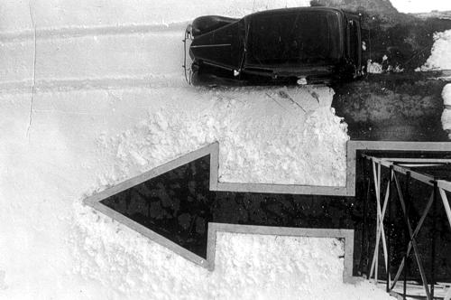
The Summit or Beacon Hill light, number 38, was located one and one-half miles north of the Lincoln Monument at T15N, R72W, Section 14, at 8777 feet. A permit was granted on July 26, 1930 to U.S. Department of Commerce, Lighthouse Service, Airways Division, to use a plot of land, 200 feet square, for beacon site and suitable buildings for caretaker of the light. The 1933 Corps of Engineer’s map indicates a power or telephone line going to the beacon. (photo 1 photo 2, photo 3, photo 4)  (41° 16′ 5″ N, 105° 26′ 2″ W) In May of 2004 the site was visited and coordinates confirmed with GPS. Several newer towers now occupy the area but the concrete arrow remains. There also remains some remnants of the old generator system and building foundation.

Beacon number 39 was in Section 33, T15N, R70W about ¾ mile north of McIntyre’s. The elevation is shown as 7528 feet. (photo 1, photo 2, photo 3)

From Happy Jack Road 210 take County road 1 ½ miles to a more or less double turnoff to the east. Take the left branch about 1 ½ mile to the center of Section 33. (Land ownership??)

(41° 13″ 34″ N, 105° 14′ 36″ W) In May of 2004 the site was visited and coordinates checked by GPS. The concrete arrow remains but no buildings.

The Silver Crown Beacon number 40 was located almost dead center of Section 7, T14N, R68W at 41° 11′ 49″ N, 105° 02′ 53″ W. The elevation is about 6729 feet. (Of note: On the Round Top Lake Quadrangle 7.5 minute of 1961, “Airline Camp” is shown located in Section 3, T14N, R68W. This is close to the site of the 1935 airline crash.)

On the Archer Quadrangle of 1963, a beacon is shown located in Section 21 of T14N, R 65W, about one half-mile northwest of U.S. 30 overpass. This was probably beacon number 42. There is no remaining portion of the beacon tower or base.

(41° 09′ 53″ N, 104° 40′ 28″ W)

In 1932 the standard airway beacon was a 24-inch rotating unit of approximately 1 million candlepower. In 1933 a new standard was adapted to utilize a 36-inch rotating unit which showed two beacons of light 180 degrees apart. Each beam was about 1,250,000 candlepower. The beacons were designed to show six flashes per minute. The older 24-inch unit rotated six times per minute and the newer 36-inch unit rotated 3 times per minute. The 24-inch beacons were spaced at 10 mile intervals. The newer 36-inch units allowed spacing up to 15 miles between units. Except for the number 8, LeRoy Beacon, the Wyoming beacons were all 24 inch units and retained their original spacing of about 10 miles. The LeRoy Beacon had a 36-inch light. Two blinking colored course lights were mounted with each beacon, green indicating the presence of a landing facility and red indicating the absence of a landing field. In addition, each beacon course light blinked a code indicating which beacon was being observed. Every ten beacons the code was repeated.

The Silver Crown Beacon for example flashed two dashes for identification. The same signal was used by Sidney, approximately 100 miles away.

Electricity for remote sites required a gasoline-powered generator. In isolated regions permanent quarters were provided for the caretaker of the power plant generator.

Some of these beacon sites were also utilized for the newer radio beacons that were being installed in the early 1930s. The light beacons were retained at these sites. In 1933, radio range beacons were installed at Knight, Rock Springs and Cheyenne. By 1936, additional radio range beacons were installed at Laramie and Medicine Bow.

The building roof at each beacon site along the airway was marked with its number and SL-O indicating that you were on the Salt Lake to Omaha Airway. For example, Cherokee Beacon had on its roof “24 SL-O”.

The beacons at the airports were normally located on the highest point of land or atop a building near the site rather than being centered at the landing field.

It behooved a pilot to know his International Morse Code quite well. Cheyenne’s auxiliary code beacon flashed the letter “C” (dash dot dash dot), its radio range station broadcast “CX” (dash dot dash dot, dash dot dot dash) and the course light blinked a modified code for the numeral 1, (dot dot dash).

Intermediate landing fields were provided about every 50 miles affording a theoretical maximum distance of 25 miles to a field in the event of a problem. These intermediate fields were indeed just fields. None of them were paved or oiled and most had a landing space of about 2500 feet.

In 1936, only Cheyenne and Laramie were listed as “Airports” and only Cheyenne had paved or oiled runways. Laramie Airport has a restored beacon and tower. The beacon appears to be a 36 inch double unit.

The above historical article was written and submitted by Mel Duncan of Wyoming, May 2004.