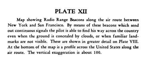
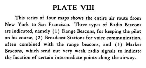
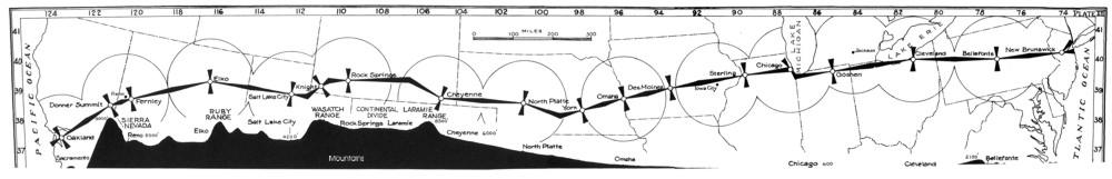
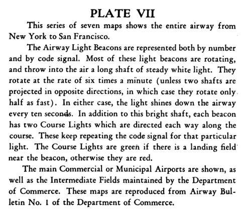
Index of /History/Maps
Name
Last modified
Size
Description
Parent Directory
-
1948_WAC_363_(Mt Whi..>
2016-10-27 08:26
2.4K
1948_WAC(Mt Whitney-..>
2016-10-27 08:26
2.8K
Thumbs.db
2016-10-27 08:26
5.0K
Airway_PlateXII.jpg
2016-10-27 08:26
21K
Airway_PlateVIII.jpg
2016-10-27 08:26
25K
Oakland-NewBrunswick..>
2016-10-27 08:26
31K
Airway_PlateVII.jpg
2016-10-27 08:26
45K
Dept_of_Commerce_Aer..>
2016-10-27 08:26
63K
Omaha-Chicago_Airway..>
2016-10-27 08:26
76K
Sectional&Strip_Airw..>
2016-10-27 08:26
77K
Dept_of_Commerce_Aer..>
2016-10-27 08:26
89K
RadioFacilityMapNW_Q..>
2016-10-27 08:26
95K
SaltLakeCity-Omaha_R..>
2016-10-27 08:26
99K
SaltLakeCity-Omaha_S..>
2016-10-27 08:26
122K
SaltLakeCity-Omaha_A..>
2016-10-27 08:26
123K
SanFrancisco-SaltLak..>
2016-10-27 08:26
124K
SanFrancisco-SaltLak..>
2016-10-27 08:26
125K
us_aeronautical_radi..>
2016-10-27 08:26
138K
Omaha-Chicago_IowaCi..>
2016-10-27 08:26
138K
Chicago-NewYork_Merc..>
2016-10-27 08:26
138K
SanFrancisco-Reno-El..>
2016-10-27 08:26
143K
1944sectional_chart.jpg
2016-10-27 08:26
164K
1948_WAC_363_(Mt Whi..>
2016-10-27 08:26
2.3M
1948_WAC(Mt Whitney-..>
2016-10-27 08:26
3.2M
1948_WAC(Mt Whitney-..>
2016-10-27 08:26
6.3M
us_aeronautical_radi..>
2016-10-27 08:26
6.7M
Back_small.jpg)
Front_small.jpg)
Back.jpg)
Front2000p.jpg)
Front.jpg)